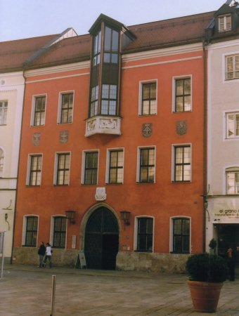
Höhenfestpunkt am Rathaus in Traunstein
(Deutschland) /
Elevation point at the main hall of Traunstein (Germany)
Der Höhenfestpunkt am Rathaus der oberbayerischen Stadt Traunstein ist
selbstredend kein Koordinatenursprung. Aber über ihm ist eine Informationstafel
angebracht, die Hinweise auf verschiedene Koordinatenursprünge enthält
beziehungsweise aufzeigt. Dies rechtfertigt eine Berücksichtigung in diesem
Zusammenhang.
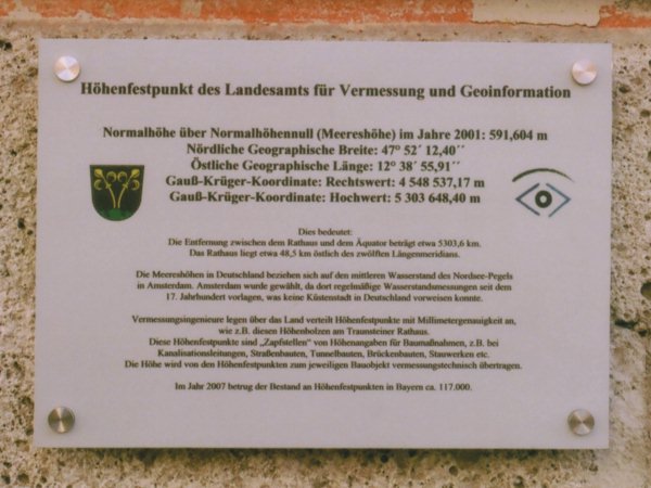
Der Text dieser Informationstafel lautet:
Höhenfestpunkt des Landesamts für Vermessung und
Geoinformation Normalhöhe über
Normalhöhennull
(Meereshöhe)
im Jahre 2001: 591,604 m Nördliche
Geographische Breite:
47° 52'
12,40" Östliche
Geographische
Länge: 12° 38'
55,91" Gauß-Krüger-Koordinate: Rechtswert: 4 548 537,17
m Gauß-Krüger-Koordinate: Hochwert: 5 303 648,40 m
Dies bedeutet: Die Entfernung zwischen dem Rathaus und dem Äquator beträgt
etwa 5303,6 km. Das Rathaus liegt etwa 48,5 km östlich des zwölften
Längenmeridians.
Die Meereshöhen in Deutschland beziehen sich auf den mittleren Wasserstand des
Nordsee-Pegels in Amsterdam. Amsterdam wurde gewählt, da dort
regelmäßige Wasserstandsmessungen seit dem 17. Jahrhundert vorlagen, was
keine Küstenstadt in Deutschland vorweisen konnte.
Vermessungsingenieure legen über das Land verteilt Höhenfestpunkte mit
Millimetergenauigkeit an, wie z. B. diesen Höhenbolzen am Traunsteiner
Rathaus. Diese Höhenfestpunkte sind "Zapfstellen" von Höhenangaben für
Baumaßnahmen, z. B. bei Kanalisationsleitungen, Straßenbauten, Tunnelbauten,
Brückenbauten, Stauwerken etc. Die Höhe wird von den Höhenfestpunkten
zum jeweiligen Bauobjekt vermessungstechnisch übertragen.
Im Jahr 2007 betrug der Bestand an Höhenfestpunkten in Bayern ca.
117.000.
Die Fotos wurden im März 2008 aufgenommen.
The elevation point fixed at the front of the main hall of the city of Traunstein is
certainly not an origin of either kind. But above it there is an information tablet, which
provides references to several origins. This justfies the consideration in this
context.
The text of the information board may be translated as follows:
Elevation point of the office for surveying and
geoinformation Elevation above Normalhöhennull
(sea level) in the year 2001:
591,604 m Northern geographical latitude: 47° 52' 12,40" Eastern geographical
longitude: 12° 38'
55,91" Gauß Krüger coordinate: Easting: 4 548 537,17
m Gauß Krüger coordinate: Northing: 5 303 648,40 m
This means: The distance of the main hall to the Equator is about 5303,6 km. The
main hall is located approximately 48,5 km to the East of the twelveth meridian.
In Germany elevation values are related to the mean sea level of the North Sea in
Amsterdam. Amsterdam was chosen because continuous observations of the sea level are
documented from the 17th century. Uncomparably with respect to each coastal
German town.
Surveying engineers provide elevation (fixed) points in the whole country and determine
their elevation very precisely (millimeter). E. g. also this one at the main hall of the
city of Traunstein. These elevation points are basic references for elevation
measurements for constructing reasons e. g. for canalization, roads, tunnels, bridges,
barrages etc. In
2007 there have been approximately 117000 elevation (fixed) points in Bavaria.