
![]() Im Obergeschoss des Deutschen Historischen Museum ist auch
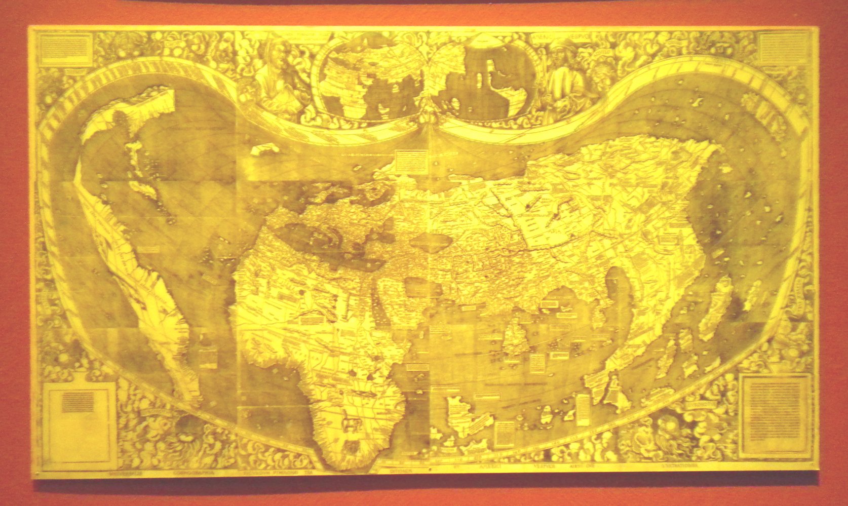
eine Kopie der Weltkarte aus dem Jahr 1507 von
Martin
Waldseemüller1) ausgestellt. Sie ist die erste
Landkarte, die den amerikanischen Kontinent zeigt. Am oberen Bildrand ist sie mit
Porträts von Claudius Ptolemäus und Amerigo Vespucci ausgeschmückt.
Im Obergeschoss des Deutschen Historischen Museum ist auch
eine Kopie der Weltkarte aus dem Jahr 1507 von
Martin
Waldseemüller1) ausgestellt. Sie ist die erste
Landkarte, die den amerikanischen Kontinent zeigt. Am oberen Bildrand ist sie mit
Porträts von Claudius Ptolemäus und Amerigo Vespucci ausgeschmückt.
Die Erläuterungen zu diesem Exponat werden nachstehend wiedergegeben:
| Weltkarte Martin Waldseemüller 1470 - 1518 St. Dié 1507 Holzschnitt © Library of Congress, Geography and Map Division, Washington Seit Anfertigung des Behaim-Globus waren die Fahrten von Kolumbus, Vasco da Gama und Vespucci erfolgt. Durch ihre Informationen veränderten sich die Kartenbilder nur langsam. Die gedruckten Karten aus Italien und Deutschland verbreiteten die neuen Erkenntnisse. Wappenpfeiler dokumentieren die Ansprüche der portugiesischen Krone, wichtige Stützpunkte sind genannt. Ptolemäus und Verspucci sind als Paten des Weltbildes dargestellt. |
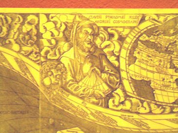
Nachstehend wird der Ausschnitt mit der Darstellung von Claudius Ptolemäus vergrößert wiedergegeben.
Im Jahr 2007 wurde von der Deutschen Post eine Briefmarke herausgegeben, welche diese Weltkarte als Motiv besitzt. Diese wird am Ende dieser Seite noch einmal wiedergegeben.
Die Fotos wurden im Oktober 2012 aufgenommen.
1) Gemäß diesem Artikel der Online-Enzyklopädie Wikipedia hat M. Waldseemüller in Freiburg im Breisgau Mathematik und Geografie studiert. (Zurück zum Bezug)
![]() In its upper floor the German Historical Museum
also exhibits a copy of the wordmap from 1507 created by
Martin
Waldseemüller1). Itis the first map which
shows the continent America. Near the upper boundary of the map are portraits of Claudius
Polemy and Amerigo Vespucci.
In its upper floor the German Historical Museum
also exhibits a copy of the wordmap from 1507 created by
Martin
Waldseemüller1). Itis the first map which
shows the continent America. Near the upper boundary of the map are portraits of Claudius
Polemy and Amerigo Vespucci.
The explanations for this exhibit read like:
| Worldmap Martin Waldseemüller 1470 - 1518 St. Dié 1507 woodcut © Library of Congress, Geography and Map Division, Washington Since preparation of the Behaim-globe the cruises of Columbus, Vasco da Gama, and Vespucci took place. Due to their discoveries the maps changed but rather slowly. The printed maps from Italy and Germany spread the new knowledge. Coat of arms demonstrate the claims of the Portugese crown, important base points are displayed. Ptolemy and Verspucci are presented as patrons of the worldmap. |
Between the German and the English description the section of the worldmap with the portrait of Claudius Ptolemäus is presented in an enlarged manner.
In 2007 a stamp was issued by the Deutsche Post, which displays this worldmap. The stamp is shown again at the end of this page.
The photograph was taken in October 2012.
1) Refering to the German article with respect to Martin Waldseemüller it should be mentioned he studied mathematics and geography in Freiburg im Breisgau. (Back to the reference)

| Back to the main page | Created by Wolfgang Volk in November 2012 |