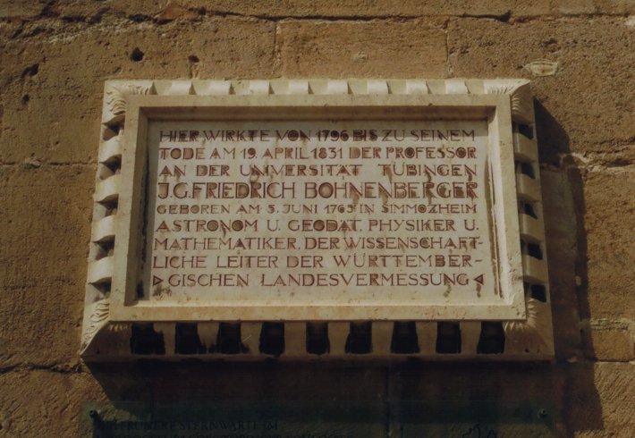

An der Nordseite des Innenhofes des über der Stadt thronenden Schlosses Hohentübingen befindet sich eine Gedenktafel zu Johann Gottlob Friedrich Bohnenberger. Das Schriftbild ihres Texts ist im Gegensatz zur gesamten Gestaltung eher schlicht gehalten. Der Wortlaut der Inschrift ist wie folgt:
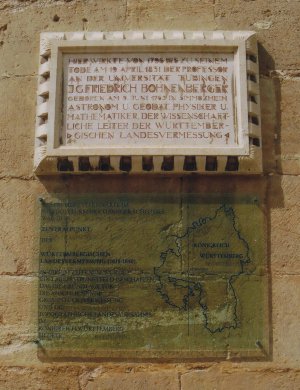
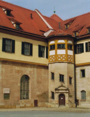
Der Zusammenhang zwischen Örtlichkeit und Person ergibt sich aus der Tatsache, dass - wie aus einer Zeittafel im Durchgang zum Innenhof entnommen werden kann - im Jahr 1762 auf dem Nordost-Turm (siehe Bild unten rechts) ein astronomisches Observatorium eingerichtet wurde und 1818 der Nordost-Turm Zentralpunkt des der Württembergischen Landesvermessung zugrunde liegenden Soldner-Koordinatensystems wurde. Letzteres wird auch durch ein transparentes Tableau unterhalb der Gedentafel dokumentiert (siehe Bild unten links). (Weitere Details können der Beschreibung dieser Tafel in der Sektion "Ursprünge" entnommen werden.)
Die Fotos wurden im August 2008 aufgenommen.
![]() At the northern wall of the courtyard of the castle Hohentübingen there is a
commemorative plaque for
Johann
Gottlob Friedrich Bohnenberger.
The layout of the text is rather modest if compared with the design of the whole plaque.
The inscription reads like:
At the northern wall of the courtyard of the castle Hohentübingen there is a
commemorative plaque for
Johann
Gottlob Friedrich Bohnenberger.
The layout of the text is rather modest if compared with the design of the whole plaque.
The inscription reads like:
The relation between location of the plaque and the person J. G. F. Bohnenberger turns to become obvious if one knows that in 1762 an astronomical observatory was established on the Northeast-tower (cf. the picture below on the right) and that exactly this tower becomes the origin of the coordinate system for Württemberg in 1818. This information is provided on a chronological table in the passageway. More details about this coordinate system are given on a transparent board (cf. section "Origins") below the commemorative plaque (cf. the picture below on the left).
The photographs were taken in August 2008.
 |
 |
| Back to the main page | Created by Wolfgang Volk in December 2009 |